This weekend’s incoming storm is coming more into focus.
The very strong coastal system remains likely to develop this weekend off the Carolina coast. The biggest impacts appear to be eastern North Carolina on Saturday, with fringe impacts to the tri-state area on Sunday.
This weekend’s storm is very different from last weekend’s storm. Last week’s storm started in the desert southwest and traversed the majority of the U.S. before slamming the Northeast with a foot or more of snow in many places.
The storm delivered massive snowfall and crippling ice to millions of people from New Mexico to New England.
This weekend’s storm, on the other hand, will develop offshore and stay offshore for the duration of its existence. That means its impacts will be confined to the immediate East Coast.

What We Know
We are confident that a storm will develop and strengthen quickly on Saturday somewhere off the coast of the Southeastern U.S. The storm will generate in response to a potent upper-atmospheric disturbance that digs into the Eastern U.S. from Canada late this week.
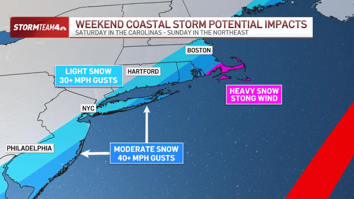
The storm will lock in cold air up and down the East Coast this weekend – all the way to Florida, where temperatures in Orlando will drop well below Freezing Sunday morning. Back here in the tri-state, that frigid air ensures that whatever precipitation we get will come as snow.
Based on the general track of the storm, we also feel strongly that the coast will get the biggest impact from Sunday’s storm.


Eastern Long Island and the south Jersey Shore could pick up moderate snow. Light snow is more likely in Nassau County, New York City, and Monmouth County. Inland areas will be much less likely to feel the effects of the storm.
The storm will generate 40+ mile per hour northeast wind gusts along the coast, with high surf churning on south and east facing shores. The full snow moon comes on Sunday, too, which will bring higher high tides and will exacerbate any flooding from the storm.
What We Don’t Know

The biggest variable that would change our forecast drastically remains the storm’s track. Any deviation, either west or east, will change the amount of snow we pick up in the tri-state.
A shift to the west, closer to the coast, would mean higher snow totals with the snow extending farther inland. A shift to the east, away from the coast, would mean we could miss out on snow entirely.
Each day our forecast confidence improves. There is certainly wiggle room between now and the weekend, so stay with Storm Team 4 each day – on air or on any of our digital platforms – to stay current on the forecast as we continue to tweak it.
Stay safe and stay warm!